Wednesday, March 30, 2011

Weather Conditions for Wednesday, March 30th 2011

The weather this week has been abnormal for late March weather. The temperatures are much lower than usual. It tends to warm up slightly during the day, but it's still cooler than usual. The low for today is 25 (for tonight), and it is currently 39 degrees out. The wind is coming in from the NW, at around 3 mph. There wasn't a lot of cloud coverage from what I could see this morning, except for a few cirrus clouds.

Graphic courtesy of The Weather Channel - http://www.weather.com/


If you look at the current weather map, there are a lot of strange things going on. There are two low pressure systems, right near two high pressure systems in the central part of the country. Along with the two cold fronts in the south eastern states. As you can see, there really isn't a lot going on in our part of the country at the moment.

One good thing about this weather is that the cooler temperatures at night and the slightly warmer temps during the day are slowing down the melting snow. It is taking a lot longer for the snow to melt, which is better for our area flood-wise. There probably won't be as severe of a flood that they were predicting before because of this.


Tuesday, March 22, 2011

Crazy weather in Appleton, WI

Right now I'm on Spring Break, so I'm not in Eau Claire, I'm in my hometown of Appleton, WI. I just felt the need to post about the weirdest weather I've ever seen in my life (I'm sure this happens a lot in the spring, I'm just not used to it). This morning in Appleton we had snow, which then turned to rain, and then turned to sleet. At one point it felt like it was doing all three at the same time.

It has been sleeting now in Appleton for about 8 hours, and there is quite an accumulation of sleet on the ground. The sleet has been mixed with thunderstorms, so it has been sleeting and thundering and lightning for quite a while now.

Graphic courtesy of The Weather Channel - http://www.weather.com/

If we look at the current weather map we can see a low pressure system as well as a warm front that may be causing this weather. The higher temperatures in the lower part of the state are causing the precipitation to be rain, and in the northern part of the state the precipitation is snow due to the lower temperatures. In between we have the sleet, which is where Appleton lies at the moment.

Graphic courtesy of The Weather Channel - http://www.weather.com/


Another interesting thing to look at is the amount of lightning strikes in the area. A lot of these lightning strikes are occurring in the middle of blizzard-like conditions. There have been quite a few strikes in the past couple hours here in Appleton, and they are all very bright, loud, cloud-to-ground lighting strikes. So this is definitely weird weather, that I felt seemed "blog-worthy".

Wednesday, March 16, 2011

Weather Conditions for Wednesday, March 16th 2011

Early this morning (8:30... that's early for me) it was foggy (most likely evaporation fog, left over from last night) and there was frost everywhere, which had to be hoar frost since it was so clear and cooler outside.


Photo taken by me.

Here is a picture of a cool design the hoar frost left on my car this morning.

Throughout the day the temperature rose steadily. It is currently 48 degrees and the low tonight isn't supposed to get below 38 degrees! Cloud coverage this morning was below 30% with a few cirrus clouds. Currently according to Intellicast it is 80%. The wind is SSE at around 12 mph.

Graphic courtesy of The Weather Channel - http://www.weather.com/


If we look at this graphic map from The Weather Channel, we can see temperatures rising in the Midwest to the Eastern part of the country. We can also see the Jet Stream moving steadily across our area & also notice a trough in the Jet Stream to the west of us, which could result in cooler temperatures in that part of the country.

Weather Conditions for Tuesday March 15th, 2011

Yesterday (Tuesday), it was warm most of the day! I believe the temperature was above 40 at one point. The cloud coverage was around 25 to 30%, and from what I could tell they seemed to be Cirrostratus clouds.


The high point of the day (for me at least) was rain! It rained in the evening for quite a while. I also noticed while walking out of my night class around 9 o'clock, that there was some fog. I would assume this was evaporation fog caused by the melting snow.

Monday, March 14, 2011

Weather Conditions for Monday, March 14th 2011

Well, it was definitely a bit cooler this morning, which could have been the result of that cold front that moved through yesterday/last night, but this afternoon it was absolutely beautiful outside! I checked my phone around 2 o'clock and it was around 40 degrees! There was also 0% cloud coverage today, and it was bright, sunny and beautiful. Right now it is almost 11 pm and the temperature is still 30 degrees. The low for tonight is supposed to get to 19 degrees. Wind is calm, and coming in from the SSE.

Graphic courtesy of The Weather Channel - http://www.weather.com/


As you can see on the current surface map, there is not a whole lot of activity in our area. There's a large cold front along with a low pressure system causing some precipitation in the Southern states, but nothing near us... although the National Weather Service is predicting a 30% chance of RAIN late tomorrow. Did you hear that??? RAIN!!! Not snow!!

Although rain is exciting, especially the first rain fall of spring, it isn't such good news for us at the moment due to how high risk our area is for flooding. According to the National Weather Service, our area is currently in a "hydrologic outlook" area, meaning "...WARM TEMPERATURES THIS WEEK ARE EXPECTED TO INCREASE MELTING AND POTENTIALLY LEAD TO RIVER FLOODING AS EARLY AS THIS WEEKEND AND INTO EARLY NEXT WEEK..."

So we'll have to keep an eye on that!

Sunday, March 13, 2011

Weather Conditons for Sunday, March 13th 2011

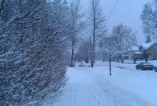
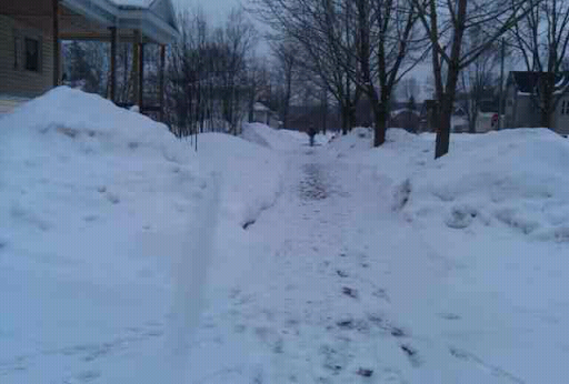
It looks like a nice day outside, I haven't noticed any clouds this afternoon, the sun in shining and the snow is melting (yes!). The current temperature is 31 degrees with a WNW wind at 4 mph. The low for tonight is predicted to be 20 degrees.

Photo courtesy of The Weather Channel - http://www.weather.com/

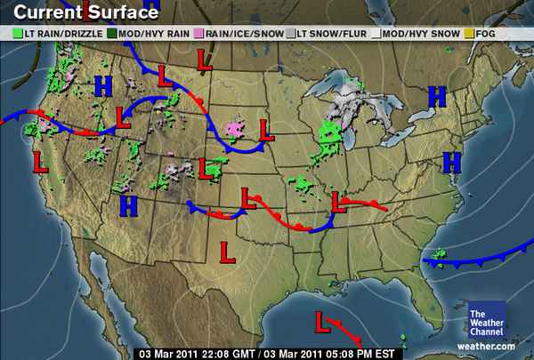
If we take a look at the surface map (above) you can see a cold front moving in our direction. Normally I would say that this would cause the temperatures to decrease for tomorrow, but according to The Weather Channel, and Intellicast, the high for tomorrow is supposed to be 38 degrees, which is 7 degrees higher than it is today, so we may not see such a huge drop in temperature because of this cold front, unless it just occurs overnight.

As most people may know, a huge earthquake occurred in Japan Thursday night causing a tsunami, a whirlpool, and an incredibly large amount of damage.


 (AP Photo/Kyodo News)

There is a very interesting part of http://www.intellicast.com/ where you can see all the major earthquakes that have happened recently on a map. Here is the link o the map. http://www.intellicast.com/Local/WxMap.aspx

After opening the link, zoom all the way out so you can see the map of the whole world, and move the map so you can focus on the "Ring of Fire" area. Then at the top of the map under "Quick Picks" choose the icon for Earthquakes, the last one before the purple "Full Screen" icon. If you hover over the large circles, it will tell you exactly where the earthquakes were, and what their magnitude is. You will notice that Japan is still having a huge amount of aftershocks, and that there have also been some recent smaller earthquakes in parts of the U.S like California, Alaska, Texas, and Arkansas. There is also a link to this map in my "Links" section.

Weather Conditions for the week of March 7th, 2011

Unfortunately midterms kept me busy the last couple weeks, so this last week I forgot to post updates on the Weather! So here is a little summary.

The big event of the week was the mini snowstorm we had on Wednesday. It was caused by the large frontal system that swept across the country affected both the northern and southern states.

Photo taken by me.

This picture was taken on my morning walk to class, around 9:30am. The snow began Tuesday night/Wednesday morning and continued until the afternoon. By evening it was done. The temperatures that day stayed in the low 30's.

Thursday was partly cloudy with what I would call Cumulus clouds. Sky coverage was probably at about 25-30% for most of the day. Earlier in the morning it was completely clear, with sky coverage at 0%. Clouds started to move in around 11 or noon.

On Friday it was sunny, I didn't notice the clouds that day. Early on in the morning there was a bit of evaporation fog, caused by the melting of the snow, along with hoar frost on the trees and ground. The temperatures were cooler later that evening, in the 20's.

Saturday it was overcast mostly to all of the day, with a blanket of stratus clouds. The temperatures remained in the low 30's for most of the day.

Monday, March 7, 2011

Weather Conditions for Monday, March 7th 2011


Photo taken by myself.

This morning's walk to class was quite a snowy one. There was a continuous snowfall most of the morning, that accumulated to over 1 inch. The current temperature is 32 degrees, and the low for tonight is predicted to be 24 degrees. The wind is coming from the NNW, at around 4 mph, and there is 100% cloud coverage. The precipitation could be due to the stationary front that has moved through our area, that can be seen in the following surface map.

Graphic courtesy of The Weather Channel - http://www.weather.com/


A frontal system is predicted to move across the country Tuesday and Wednesday, resulting in snow in the northern states and severe thunderstorms in the southern states. The snow is predicted to start in our area Tuesday night into Wednesday.

Graphic courtesy of The Weather Channel - http://www.weather.com/


Thursday, March 3, 2011

Weather Conditions for Thursday, March 3rd 2011

My predictions yesterday of snow showers were correct, it was snowing on and off almost all morning from what I could tell. The snow seems to have moved out of our area for now though, and it is currently overcast with temperatures around 30 degrees. The wind is from the SE (another prediction I got correct from yesterday) which is why it is much warmer than yesterday. That and the fact that our cold front has moved through.

Graphic courtesy of The Weather Channel - http://www.weather.com/


As you can see from the above surface map, all precipitation has moved out of our area. There seems to be no major activity in the area as far as warm/cold fronts and pressure systems go, although weather.com is predicting a "wintry mix" of precipitation for tonight. 

Wednesday, March 2, 2011

Weather Conditions for Wednesday, March 2nd 2011

My predictions yesterday were correct! It was DEFINITELY colder today than it was yesterday due to the cold front that moved through. Right now at about quarter to 7 it is 14 degrees outside with a wind chill of 6 degrees. The winds are coming from the North at about 5 mph, but after this front moves through, I predict we will have some Southern winds to warm up those temperatures again.

Graphic courtesy of The Weather Channel - http://www.weather.com/


As you can see from the surface map, the cold front that was just in our area is now reaching Georgia, Mississippi, and Alabama, and it looks like a High pressure system is moving into our area, which could bring us some precipitation tomorrow. We'll just have to wait and see!

Tuesday, March 1, 2011

Weather Conditions for Monday February 28th, and Tuesday March 1st 2011

Yesterday was a beautiful day, even though it was still pretty cold out. My phone was telling me it was 19 degrees around 2 o'clock. There was hardly a cloud in the sky, except for a couple cirrus clouds, but overall beautiful and sunny!

Today it is already 10 am and the temperature is 26 degrees, and weather.com is predicting it to get up to 41 degrees! It will be nice to see some of this snow melt. There is a SSW wind at around 12 mph, which could be bringing in some of that warm air from the south.
Graphic courtesy of The Weather Channel - http://www.weather.com/

If we look at this surface map of the current winds in our country, we can see that the winds that are affecting us are coming all the way up to us from Arkansas and Missouri.

Graphic courtesy of The Weather Channel - http://www.weather.com/

If we look at the surface map of our current weather conditions, we can see a cold front to the West of us, which is another reason we may have warmer temps now, while it may slightly lower our temperatures again for tomorrow.